Mombasa County’s Rivers: Little-Known Histories, Hidden Waterways and Their Present-Day Struggle

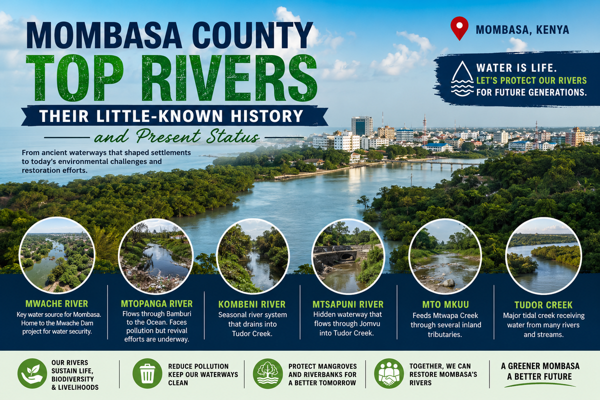
By Nestict Infotech
Mombasa, Kenya | 2026
Mombasa is usually introduced through its beaches, coral reefs, Fort Jesus, the Old Town, Likoni Ferry and the vast Indian Ocean. But beneath the familiar coastal postcard lies another story: a network of rivers, streams, creeks and seasonal waterways that has quietly shaped where people settled, how farms developed, how Mombasa grew, and even why some parts of the county flood today.
Some of these waterways are so heavily built over, narrowed or polluted that residents can pass them every day without realizing that they are standing beside a river.
Mombasa County is almost entirely urban, covering about 229.9 square kilometres. Its 2023-2027 development plan identifies water, sanitation and storm-water management among the county's major development priorities.
Here are some of the county's most interesting rivers and river systems, including the little-known history behind them and what their condition tells us about Mombasa today.
1. The Kombeni River: The River That Becomes Part of Tudor Creek
Among Mombasa's lesser-known waterways, the Kombeni River is one of the most important.
The river system begins farther inland, where the Magambo and Madzimbo streams originate around the Nyika Plateau and Maji ya Chumvi area. They meet around Mariakani and form the Kombeni stream. The Mwangata stream subsequently joins the system before the water eventually reaches Tudor Creek at Kisauni.
That geography makes the Kombeni much more than a small local stream.
It is part of the natural drainage system connecting inland areas with one of Mombasa's major tidal creeks.
A little-known historical connection
The development of Mombasa was never determined solely by roads and buildings. Watercourses helped determine movement, settlement and agriculture.
Older planning documents describe Mombasa's landscape as one shaped by erosion, coastal valleys and the later submergence of those valleys, producing the deep creeks and harbour systems surrounding Mombasa Island.
The Kombeni system therefore belongs to the older geographical machinery that helped create the coastal landscape we recognize today.
Present status
Kombeni is essentially a seasonal river system, rather than a large permanently flowing river. Studies of the coastal region describe the Kombeni and Mwache systems as seasonal but capable of carrying substantial flows during wet periods.
That creates a strange urban paradox.
For much of the year a seasonal river may look insignificant. During heavy rainfall, however, the same drainage system can suddenly become extremely important.
This is one reason preserving river corridors matters even when there appears to be very little water in them.
2. Mwache River: The Waterway That Could Change Mombasa's Future
If there is one river in the Mombasa region whose modern story deserves special attention, it is Mwache River.
Mwache originates west of Mombasa and flows toward Mwache Creek. It is one of the major drainage systems influencing the wider coastal region.
But Mwache's story has moved far beyond drainage.
It has become central to the region's long-term water-security strategy.
From seasonal river to strategic water resource
For decades, Mombasa's rapid population growth has placed enormous pressure on water supplies.
The solution being built around Mwache is the Mwache Multipurpose Dam, located in Kwale County but designed in large part to improve water security for Mombasa and Kwale.
As of 5 August 2026, the main dam was reported to be 90.59% complete, with reservoir impoundment scheduled to begin on 1 October 2026. Once operational, the project is expected to provide approximately 186,000 cubic metres of water per day to Mombasa and Kwale counties.
That makes Mwache one of the most consequential waterways in the region's modern history.
The fascinating twist
Mwache is not inside Mombasa County's administrative boundary in the same way that a small urban stream such as Mtopanga is.
Yet Mombasa's future water security is becoming increasingly tied to this river.
In other words, the county's water story extends beyond the county boundary.
3. Mtopanga River: The River Many Residents Almost Forgot
The Mtopanga River may be the most dramatic example of how urbanization can erase a waterway from public consciousness.
The river originates around the Nguu Tatu Hills, passes through the Bamburi area and eventually reaches the Indian Ocean. Historical environmental assessments describe it as a small stream whose route crosses the A7 near Bamburi before reaching its coastal outlet.
Today, however, Mtopanga has a very different reputation.
From waterway to waste channel
A 2024 Reuters report documented the severe deterioration of the river.
The report described sections where the once wider watercourse had been reduced to a narrow channel surrounded by accumulated plastic and solid waste. During heavy rainfall, the river can flood and make nearby roads difficult to use.
A local environmental organization cited by MESHA estimated that plastics accounted for approximately 65% of waste in the river.
The irony is striking.
A river that historically provided water and supported its surrounding landscape has become one of the visible symptoms of Mombasa's waste-management challenge.
But Mtopanga is not a lost cause
Community groups and conservation organizations have been working to restore the river.
The goal is not simply to make the waterway look attractive. Restoring it could improve drainage, reduce waste reaching the ocean, protect groundwater recharge areas and improve the quality of life around the river corridor.
Mtopanga therefore represents two possible futures for Mombasa:
a buried and polluted drainage channel, or a restored urban river.
4. Mtsapuni River: The Hidden Route to Tudor Creek
The Mtsapuni is another waterway that rarely receives the attention given to Mombasa's famous creeks.
Historical environmental documentation records that the Mtsapuni originates around the Kalliangombe/Kokotoni area, initially flowing as the Darajani before crossing the Mazeras area. It collects additional small rivulets before eventually entering Tudor Creek at Jomvu.
This is important because it demonstrates something many people miss when looking at a map of Mombasa:
A creek is often the final chapter of a river's journey, not its beginning.
The water reaching Tudor Creek can have travelled through a chain of small streams and drainage channels extending deep into the mainland.
Consequently, activities far from the coastline can eventually affect coastal waters.
Waste disposal, soil erosion, construction, agriculture and changes to natural drainage upstream can all influence the water that eventually reaches the creek.
5. Mto Mkuu and the Mtwapa Creek System
The Mtwapa Creek is technically a tidal creek rather than a river, but no discussion of Mombasa's waterways would be complete without it.
The creek's river contribution includes the Mto Mkuu system, which itself is fed by several tributaries including Dzibana, Tsunguni and Lwondonyi. These waterways originate around the Kaloleni landmass before joining downstream and eventually feeding Mtwapa Creek.
This creates an impressive hidden network:
small inland streams → Mto Mkuu → Mtwapa Creek → Indian Ocean
To a visitor standing at Mtwapa Creek, the water looks like one enormous coastal feature.
Its freshwater story, however, begins much farther inland.
6. The Creeks of Mombasa: Rivers' Final Destination
Mombasa's famous waterways are actually dominated by tidal creeks and estuaries.
Tudor Creek, Makupa Creek, Kilindini Harbour and Mtwapa Creek are among the defining water bodies of the metropolitan landscape.
Mombasa Island itself exists within this extraordinary geography.
The historical development of the island and its harbour was strongly influenced by coastal valleys that were subsequently submerged as sea levels changed, producing the deep natural creeks and harbour systems that surround the island.
These waterways were not merely scenery.
They helped make Mombasa a natural maritime centre.
Ships, fishing communities, traders and later industrial activities all depended on the coastal geography.
7. Why Mombasa Floods Even When the Ocean Is Calm
One of the most misunderstood aspects of Mombasa's water system is flooding.
People often see flooding as simply "too much rain."
The reality is more complicated.
Mombasa's natural drainage network has been progressively modified by:
- roads;
- buildings;
- concrete surfaces;
- blocked drains;
- informal development;
- waste accumulation;
- construction across drainage corridors;
- loss of natural vegetation;
- and inadequate storm-water infrastructure.
The county's own planning documents identify storm-water management as an important development issue. Earlier county planning documents also identified deteriorating drainage infrastructure and flooding among local development challenges.
A river does not need to be large to cause a major flood.
A narrow seasonal watercourse can become a powerful drainage channel within hours of intense rainfall.
8. The Ocean Is Part of the River Story
Perhaps the biggest mistake is to think of Mombasa's rivers and the Indian Ocean as separate subjects.
They are one connected system.
Water moves from inland catchments into streams, then into rivers and creeks, and ultimately into the ocean.
Unfortunately, the same journey can carry:
plastic + sewage + sediment + industrial pollutants + other urban waste → coastal waters
Research into Mombasa's coastal waters has documented elevated nutrient concentrations in areas including Tudor, Mtwapa and Makupa creeks, with sediments capable of retaining nutrients and releasing them again when disturbed.
The consequences extend beyond environmental aesthetics.
Mombasa's marine ecosystems support fishing, tourism, transport and coastal livelihoods.
A polluted river is therefore not merely a "dirty river."
It can become an upstream problem for the ocean economy.
9. One of Mombasa's Biggest Water Problems Is Actually Plastic
The Mtopanga story illustrates a wider problem.
Plastic waste does not necessarily remain where it is thrown.
A bottle discarded beside a road can be washed into a drainage channel.
The drainage channel can feed a stream.
The stream can feed a river.
The river can feed a creek.
And the creek can eventually deliver the waste to the Indian Ocean.
That journey can happen surprisingly quickly during heavy rainfall.
The 2024 Reuters investigation into Mtopanga highlighted how accumulated waste can narrow the effective river channel and worsen flooding while simultaneously transporting plastic toward the coast.
Mombasa's waste-management problem is therefore also a river-management problem.
10. What Is the Present State of Mombasa's Rivers?
The picture in 2026 is mixed.
Some waterways are under severe environmental pressure
Mtopanga provides the clearest example, with serious plastic pollution and degraded riverbanks documented in recent years.
Some waterways remain primarily seasonal
Kombeni, Mwache and other coastal drainage systems can carry substantial flows during rainy periods but are not equivalent to Kenya's major perennial rivers.
Some waterways are becoming strategic infrastructure
Mwache is now associated with one of the Coast's largest water-security investments, with the dam project approaching impoundment in October 2026.
The wider drainage system remains under development pressure
Mombasa's current development planning continues to emphasize water, sanitation and storm-water services, reflecting the importance of managing water in a densely urbanized county.
11. The Little-Known Lesson: Mombasa Is a Water City
When people say "Mombasa," they usually think ocean.
But Mombasa is also:
rivers + streams + creeks + mangroves + groundwater + storm water + tidal channels + ocean.
Its history is inseparable from water.
The harbour made Mombasa a trading centre.
The creeks shaped the island.
The rivers supplied drainage and supported settlements inland.
The seasonal streams helped shape the landscape.
And today, the same waterways are telling us something uncomfortable about rapid urbanization.
When a river disappears beneath garbage, concrete or construction, the water does not disappear.
It simply finds another route.
Sometimes that route is a flooded road.
Sometimes it is a blocked drainage system.
Sometimes it is a polluted creek.
And eventually, very often, it is the Indian Ocean.
12. A River Revival Could Become Part of Mombasa's Future
The future of Mombasa's waterways does not necessarily have to be a story of decline.
There is an opportunity to treat rivers as infrastructure rather than obstacles.
That means protecting river reserves, restoring natural channels, improving waste collection, preventing dumping, maintaining storm drains, restoring vegetation and integrating waterways into urban planning.
The Mtopanga experience demonstrates that community involvement can be part of this solution. Meanwhile, the Mwache project demonstrates how seriously water resources are being considered in the region's long-term development strategy.
Mombasa could eventually develop a network of restored urban waterways that serve several purposes simultaneously:
- flood management;
- environmental conservation;
- groundwater protection;
- public recreation;
- education;
- biodiversity;
- cleaner coastal waters;
- and improved urban aesthetics.
That would turn today's forgotten waterways into tomorrow's environmental assets.
The Mombasa River Map We Rarely See
The next time you cross a bridge in Bamburi, Kisauni, Jomvu, Mazeras or Mtopanga, look beyond the traffic.
There may be a river beneath you.
It may be tiny.
It may be seasonal.
It may be buried beneath years of urban growth.
But it is part of a much older geographical story.
Kombeni flows toward Tudor Creek.
Mtsapuni finds Tudor Creek through Jomvu.
Mtopanga reaches the ocean around Bamburi.
Mto Mkuu feeds Mtwapa Creek.
Mwache feeds Mwache Creek and is now becoming central to regional water security.
Together, these waterways reveal a different Mombasa: not simply a city beside the ocean, but a city built around a complex network of water.
And perhaps the most important chapter of their history is not the one already written.
It is the one Mombasa chooses to write next.
Quick Reference: Mombasa's Important Waterways
| Waterway | Type | Key connection | Major present issue/opportunity |
|---|---|---|---|
| Mwache River | Seasonal river | Mwache Creek | Major regional water-security project |
| Kombeni River | Seasonal river/stream system | Tudor Creek | Flooding and catchment management |
| Mtopanga River | Small river/stream | Indian Ocean | Severe plastic and solid-waste pollution |
| Mtsapuni | Seasonal stream system | Tudor Creek | Urban drainage and catchment protection |
| Mto Mkuu | River/tributary system | Mtwapa Creek | Connects inland streams to coastal waters |
| Tudor Creek | Tidal creek/estuary | Indian Ocean | Pollution, sanitation and urban pressure |
| Mtwapa Creek | Tidal creek/estuary | Indian Ocean | Ecological and urban pressures |
| Makupa Creek | Tidal creek/estuary | Indian Ocean | Urban and wastewater pressures |
Sources and further reading
The principal sources for this article include the Mombasa County Integrated Development Plan 2023-2027, Mombasa's strategic urban development documentation, World Bank coastal water studies, environmental assessments of the coastal road corridor, recent reporting on Mtopanga River, and the official 2026 Mwache Dam project update.
Editorial note: In common usage, people may call several of these waterways "rivers." Hydrologically, however, some are streams or tributaries, while Tudor, Mtwapa and Makupa are tidal creeks/estuaries. The distinction matters when discussing their ecology and management.